
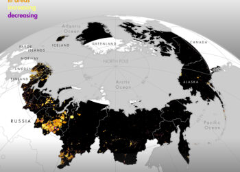
Satellite data on artificial nighttime light indicates rapid increase in industrial activities in the Arctic
More than 800,000 km2 of the Arctic were affected by human activity in 2013, according to an analysis of satellite ...

More than 800,000 km2 of the Arctic were affected by human activity in 2013, according to an analysis of satellite ...
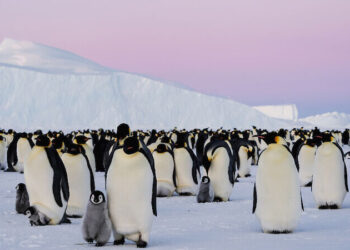
New Australian research using satellite imagery to monitor the location of emperor penguin colonies in East Antarctica shows the birds ...
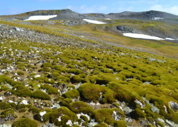
Vegetation cover on the Antarctic Peninsula has increased more than 10-fold over the past four decades, new research shows. The ...

A new analysis of satellite data reveals that the record increase in atmospheric methane emissions between 2020 and 2022 was ...
A new American satellite expected to significantly improve predictions of solar storms, events capable of disrupting electrical and communications networks ...
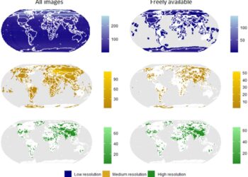
A large number of historic Cold War-era spy satellite photographs were declassified decades ago. This valuable remote sensing data has ...

An estimated 11,000 square miles or 28,707 square kilometers of Greenland's ice sheet and glaciers have melted over the past ...
NASA's newest climate satellite went into orbit Thursday to study the planet's oceans and atmosphere in never-before-seen detail. SpaceX launched ...
The two unique thin rings around Centauri Chariklo could be shaped by an even smaller satellite. Chariklo is a centaur, ...
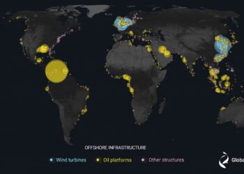
A new study published today in the journal Nature offers an unprecedented view of the previously unmapped industrial use of ...