

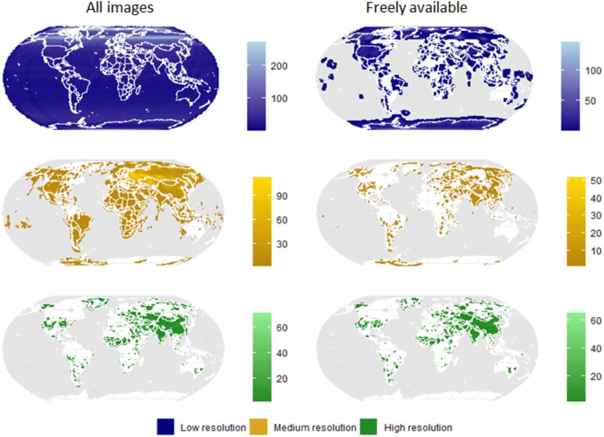
Spatial coverage and image density of spy satellite images. The data were classified into three spatial resolution classes: high (0.5 to 2.5 m), medium (6 to 12 m) or low (140 m). The left column shows image density for all data in the US Geological Survey archives, the right column only for digitized and freely accessible data. Credit: Biosciences (2024). DOI: 10.1093/biosci/biae002
A large number of historic Cold War-era spy satellite photographs were declassified decades ago. This valuable remote sensing data has been used by scientists in a wide range of disciplines, from archeology to civil engineering. However, its use in ecology and conservation remains limited.
A new study led by Dr Catalina Munteanu from the Faculty of Environment and Natural Resources at the University of Freiburg, Germany, aims to advance the application of declassified satellite data in the fields of ecology and the conversation.
Leveraging recent advances in image processing and analysis, these globally available black-and-white images can provide better insights into historical changes in ecosystems, species populations, or changes in human influences on the environment dating back to the 1960s, the researchers suggest.
Historical satellite images cover almost the entire globe, all seasons
In their study, the researchers first assessed the spatial, temporal and seasonal coverage of more than a million declassified images from four historic U.S. spy satellite programs, showing that these data cover almost the entire globe and are available in all seasons.
After examining how spy satellite imagery is currently used in areas related to ecology, the team then identified potential future applications. Importantly, the broad spatiotemporal scale of satellite images could improve understanding of ecological concepts such as baseline shifts, lag effects, and legacy effects.
This improved understanding could lead to better mapping of the historical extent and structure of ecosystems, help reconstruct past habitats and species distributions, and provide new insights into historical human impacts on current ecosystem conditions. .
In the future, this knowledge may also be useful for conservation planning and ecosystem restoration efforts by helping to identify, for example, meaningful ecological baselines, the researchers explain.
A large clearcut from the 1960s near a one-hectare forestry research plot in the southern Black Forest region. Although much of the area is forested today, historical harvests have altered the structure and composition of the forest. Left: historic image from a spy satellite. Right: Current image from Google Earth. Credit: University of Friborg
Challenges to overcome
However, the use of spy satellite data in ecological research faces several challenges. The study highlights issues such as limited data access and sharing, high costs, the need to pre-process and rectify images, and the lack of consistent workflows within the scientific community. .
To address these challenges, researchers call for collaborative efforts between data holders, remote sensing experts, and the ecological research community.
“This piece is a call for interdisciplinary collaboration between ecologists, conservationists and remote sensing specialists to explore the full potential of these incredible datasets. Our few previous studies have revealed that without considering the past, we can draw incorrect conclusions about the current state of the planet’s environment,” says Munteanu.
In a 2020 study that attracted international media attention, a research group led by the same scientists had previously presented an example of how satellite images can be used in ecology to reveal unexpected declines in marmot populations steppes due to historical agricultural conversions.
“To enable these scientific investigations, we enlist the support of data holders for the publication and pre-processing of the data,” adds Munteanu.
More information:
Catalina Munteanu et al, The potential of historical spy satellite imagery to support ecology and conservation research, Biosciences (2024). DOI: 10.1093/biosci/biae002
Provided by the University of Friborg
Quote: Spy satellite images offer insight into historic ecosystem changes (February 19, 2024) retrieved February 19, 2024 from
This document is subject to copyright. Apart from fair use for private study or research purposes, no part may be reproduced without written permission. The content is provided for information only.
