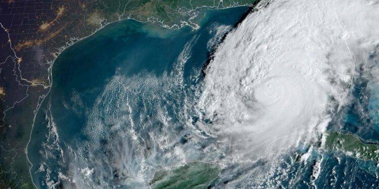
Barely two weeks after the destructive passage of the hurricane HeleneFlorida is preparing for the arrival of Milton, which makes us fear the worst. Here’s everything you need to know about the hurricane that threatens to wreak havoc in the southern US state.
• Also read: Up to 4.5 meters of water: this is how Hurricane “Milton” could wreak havoc in Florida
• Also read: An experienced meteorologist struggles to hold back tears on air
• Also read: IN PICTURES | Two ‘extremely dangerous’ tornadoes just before hurricane in Florida
1- It will make landfall tonight
Milton is expected to make landfall in Florida around 2 a.m., Wednesday night to Thursday.
A tornado warning has also been issued for more than 12 million people in central and southern Florida until 9 p.m., including Tampa, Miami, Cape Coral and Key West.
2- A category 4 hurricane
Milton, a “major and dangerous hurricane”, returned to category 4 on Wednesday morning.
It is expected to make landfall as a Category 3 or 4 hurricane.
It could be “the worst storm” to hit the state “in a century”, according to US President Joe Biden.
3- It blows winds of 249 km/h
Wednesday morning, Milton was blowing winds of 249 km/h over the Gulf of Mexico.
• Also read: Astronaut films Hurricane ‘Milton’ from space
4- It will be worse thanHelene
According to meteorological expert Michael Lowry, “if the worst forecasts materialize for the Tampa Bay region, the coastal flooding caused by Milton could be double that observed two weeks ago with Helen.”
The devastating hurricane, which caused considerable flooding and damage in half a dozen states, left at least 235 dead.
An aerial view of the damage caused by Hurricane Helene in Florida.
AFP
5- Climate change involved
Cities along the Gulf of Mexico, including those in the greater Tampa Bay area, are particularly at risk of damage from intense hurricanes like Milton, explains the specialist in climate simulations and analyzes at Ouranos, Christopher McCray.
“The warmer the oceans become, the more they will provide the energy that hurricanes feed on. This is what happened with Helene. The water temperature in the Gulf of Mexico was particularly warm, which explains why the hurricane intensified very quickly,” he emphasizes.
Last year, the surface water temperature of the Gulf of Mexico reached a record 88°F (about 31°C).
According to a report released Wednesday by the World Weather Attribution (WWA) group, the hurricane’s torrential rains and powerful winds Helene were made 10% more intense by climate change. Hurricane-sized storms Helene were previously predicted to occur once every 130 years, while today the probability is closer to once every 53 years, on average.
− With Gabriel Ouimet and AFP


