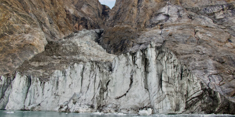
“Before” image of the landslide site taken on August 12, 2023. Credit: Søren Rysgaard
In September 2023, scientists around the world detected a mysterious seismic signal that lasted for nine consecutive days. An international team of scientists, including seismologists Alice Gabriel and Carl Ebeling of the Scripps Institution of Oceanography at the University of California, San Diego, came together to solve the mystery.
A study published in Science The solution is astonishing: In a fjord in eastern Greenland, a mountaintop collapsed into the sea, causing a gigantic tsunami about 200 meters high. The giant wave rocked back and forth in the narrow fjord for nine days, generating seismic waves that resonated through the Earth’s crust, baffling scientists around the world.
This rhythmic lapping is a phenomenon known as a seiche. Fortunately, no one was injured, but the waves destroyed some $200,000 worth of infrastructure at an unoccupied research station on Ella Island.
“When we first started this scientific adventure, everyone was puzzled and no one had any idea what was causing this signal,” said Kristian Svennevig, a geologist at the Geological Survey of Denmark and Greenland (GEUS) and lead author of the study.
“All we knew was that it was related to the landslide. We were only able to solve this puzzle thanks to a large-scale interdisciplinary and international effort.”
Climate change paved the way for the landslide by melting the glacier at the base of the mountain, destabilizing more than 25 million cubic meters of rock and ice, enough to fill 10,000 Olympic-sized swimming pools, which eventually crashed into the sea. As climate change continues to melt Earth’s polar regions, it could lead to an increase in large and destructive landslides like this one.
Image of the landslide site taken on 19 September 2023 following the event on 16 September 2023. Credit: Danish Army
“Climate change is altering the patterns of life on Earth and can trigger unusual events,” Gabriel said.
When seismic monitoring networks first detected this signal in September 2023, it came as a surprise for two main reasons. First, the signal looked nothing like the busy squiggle that earthquakes produce on seismographs. Instead, it oscillated with a 92-second interval between peaks, too slow for humans to perceive. Second, the signal remained strong for days, whereas more common seismic events weaken more quickly.
The global geological community began to speculate about the possible causes of these strange seismic waves. Discussions pointed to a massive landslide that occurred in a remote Greenland fjord on September 16, around the time the seismic signal was first detected.
To determine whether and how these two phenomena might be linked, the team, led by Kristian Svennevig of the Geological Survey of Denmark and Greenland, combined seismic recordings from around the world, field measurements, satellite images and computer simulations to reconstruct these extraordinary events.
The team, made up of 68 scientists from 41 research institutions, analyzed satellite and field images to document the enormous volume of rock and ice in the landslide that triggered the tsunami. They also analyzed seismic waves to model the dynamics and trajectory of the rock and ice avalanche as it descended the glacial gully and entered the fjord.
To understand the tsunami and the resulting seiche, researchers used supercomputers to create high-resolution simulations of the events.
“It was a big challenge to do an accurate computer simulation of a tsunami of such duration,” Gabriel said.
Ultimately, these simulations were able to faithfully reproduce the height of the real tsunami as well as the slow oscillations of the long-lasting seiche.
By integrating these various data sources, the researchers determined that the nine-day seismic signal was caused by the massive landslide and resulting seiche in Dickson Fjord in Greenland.
“It was exciting to work on such a puzzling problem with an interdisciplinary and international team of scientists,” said Robert Anthony, a geophysicist with the United States Geological Survey’s Earthquake Hazards Program and a co-author of the study.
“Ultimately, it took a multitude of geophysical observations and numerical modeling by researchers from many countries to piece together the puzzle and get a complete picture of what happened.”
The study’s findings demonstrate the complex and cascading risks posed by climate change in polar regions. Although no people were in the area at the time of the landslide and mega-tsunami, the fjord is close to a route frequently used by cruise ships, highlighting the need to monitor polar regions as climate change accelerates. For example, a landslide in Karrat Fjord, West Greenland, in 2017 triggered a tsunami that flooded the village of Nuugaatsiaq, destroying 11 homes and killing four people.
Gabriel said the findings could also prompt researchers to sift through seismic records for similar events, now that scientists know what to look for. Finding new seiches could help more clearly define the conditions that give rise to the phenomenon.
“This shows that there are things we don’t understand yet and have never seen before,” said Ebeling, who co-authored the study with NSF support and helped run a network of seismic sensors that detected the seiche’s vibrations.
“The essence of science is trying to answer a question to which we don’t know the answer. That’s why this project was so exciting.”
More information:
Kristian Svennevig, A tsunami triggered by a landslide in a Greenland fjord shook the Earth for 9 days, Science (2024). DOI: 10.1126/science.adm9247. www.science.org/doi/10.1126/science.adm9247
Provided by University of California – San Diego
Quote:Landslide triggered by climate change triggers 650-foot mega-tsunami (2024, September 12) retrieved September 12, 2024 from
This document is subject to copyright. Apart from any fair dealing for the purpose of private study or research, no part may be reproduced without written permission. The content is provided for informational purposes only.


