

Multidisciplinary approaches to urban archeology provide a wealth of information about how cities shape and are shaped by their environments. Credit: Michelle O’Reilly
Cities play a key role in climate change and biodiversity and are one of the most recognizable features of the Anthropocene. They also accelerate innovation and shape social networks, while perpetuating and intensifying inequalities. Today, more than half of humanity lives in cities, a threshold that will reach nearly 70% by the middle of the 21st century. Yet, despite their importance to the Anthropocene, cities are not a recent phenomenon.
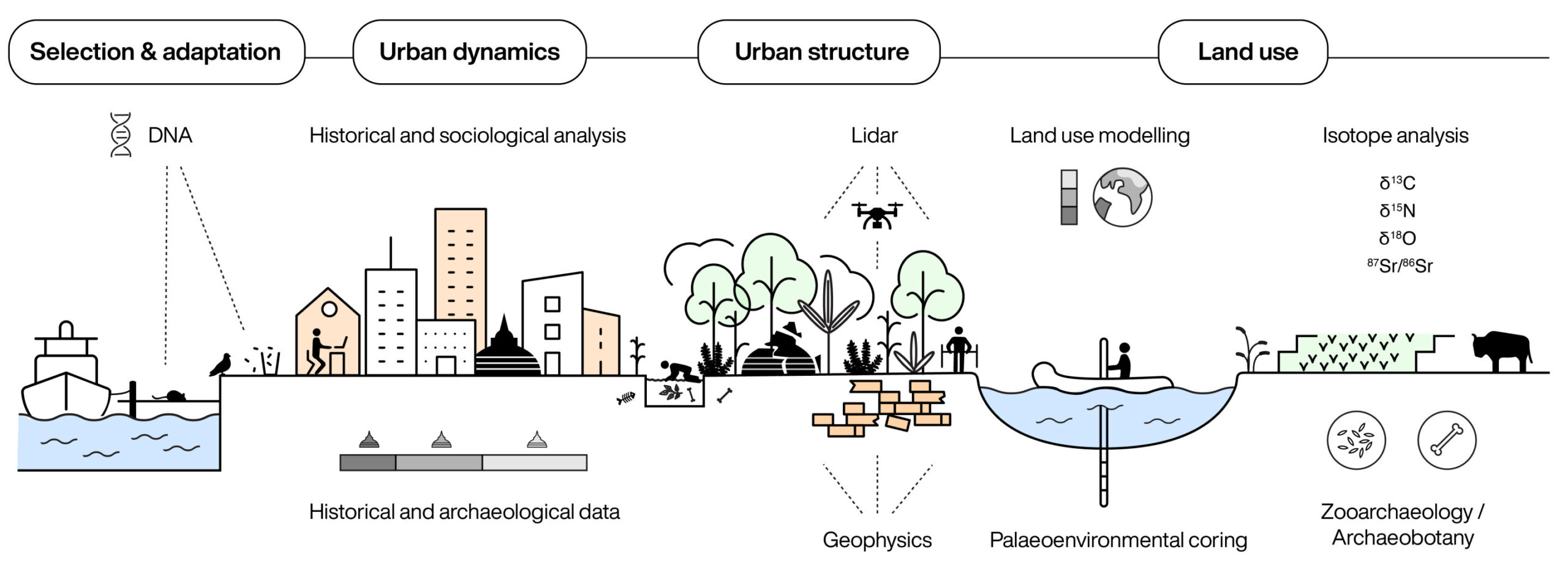
In a new study published in Nature Cities, an interdisciplinary team of authors from the Max Planck Institute for Geoanthropology argues that the history of urban planning provides an important resource for understanding where our contemporary urban challenges come from, as well as how we might begin to address them. The article highlights how new methodologies are changing our understanding of cities of the past and providing a benchmark for urban societies facing the increasingly intense climate extremes of the 21st century.
These methods range from remote sensing techniques like LiDAR, which document cities in places where urban life was once thought impossible, to biomolecular approaches like isotope analysis, which can provide insight into how cities have shaped different organisms and influenced human mobility and connectivity over time. . At the same time, studying sediment cores and historical data can show how cities have exerted adaptive pressures on different landscapes and human societies, as they still do today.
Urban planning, land use, and the Earth system are closely linked in co-evolutionary relationships, in which changes in one area lead to changes in others. Credit: Michelle O’Reilly
As understanding of humanity’s influence on the Earth system grows, urban planning is increasingly seen as one of the most impactful forms of land use. In this new study, the authors also highlight how multidisciplinary approaches, including Earth system modeling, reveal the impacts of ancient and historical forms of urban planning on land use and, importantly, how they compare to the impacts of urban areas today.
Throughout the article, the authors emphasize that the past provides not just anecdotal information, but rather numerical data sets on things like road lengths, building types, population sizes, economic production, environmental impacts, etc. With advances in computational archaeology, this opens up the possibility of quantifying similarities and differences in urban pathways across space and time, directly linking the past to the present.
Reviewing diverse examples from around the world, ranging from medieval Constantinople (now Istanbul) to 9th-century Baghdad, from Great Zimbabwe to Great Angkor in Cambodia, this new study highlights the potential for new methodological approaches to reveal the historical legacies and predicting the trajectories of urban planning around the world. the Anthropocene epoch.
More information:
Using urban pasts to talk about the urban presents of the Anthropocene, Nature Cities (2024). DOI: 10.1038/s44284-023-00014-4
Provided by the Max Planck Society
Quote: Ancient cities provide key data sets for urban planning, policy and forecasting in the Anthropocene (January 11, 2024) retrieved January 11, 2024 from
This document is subject to copyright. Apart from fair use for private study or research purposes, no part may be reproduced without written permission. The content is provided for information only.
